


A Study on the Factors Influencing Soil Organic Carbon in Cultivated Land of Fujian Province Based on Geodetector Model
-
摘要:
目的 土壤有机碳(Soil organic carbon,SOC)的空间分布及其影响因素研究对于制定合理的农业管理措施和气候变化应对政策具有重要意义。 方法 本研究基于福建省3万多个耕地土壤调查样点数据,利用皮尔逊相关系数、随机森林模型计算SOC影响因素的重要性,并通过地理探测器模型分析影响全省耕地土壤有机碳空间分布的因素。 结果 2008年福建省耕地土壤有机碳样点数据的范围在0.12~67.28 g·kg−1之间,呈现东南部沿海低、西部和中部高的空间格局。三种模型中地理探测器模型的分析结果最全面和客观。地理探测器模型的因子探测器结果表明气候相关因素是福建省耕地土壤有机碳含量空间分异性的主要影响因子,各影响因子按解释程度前六名分别为:年降水量(0.1685)>年均温(0.1677)>海拔(0.1499)>气候类型(0.1359)>土壤类型(0.0824)>地貌类型(0.0731)。通过交互探测器进一步发现年降水量与年均温的交互作用对SOC空间分异的解释程度最大(0.1941),其次为年降水量与土壤类型(0.1923)、年降水量与耕地利用类型(0.1918)。 结论 强烈的因子交互作用表明,福建省耕地土壤有机碳含量空间分异性是由多种因子共同作用影响而非单一因子决定,对SOC进行研究需要考虑其复杂的空间分异特征。本研究可为提高耕地土壤的空间使用效率、合理布局农业生产提供科学依据。 Abstract:Objective The spatial distribution and influencing factors of soil organic carbon (SOC) are of great significance for formulating reasonable agricultural management measures and climate change response policies. Method This study is based on data from over 30000 farmland soil survey sites in Fujian Province. Pearson correlation coefficient and random forest model are used to calculate the importance of SOC influencing factors, and Geodetector model is used to analyze the factors affecting the spatial distribution of soil organic carbon in farmland throughout the province. Result The range of soil organic carbon sample data for cultivated land in Fujian Province in 2008 was between 0.12 and 67.28 g·kg−1, showing a spatial pattern of low coastal areas in the southeast and high in the west and central regions. The analysis results of the Geodetector model are the most comprehensive and objective among the three models. The results of factor detector of the Geodetector model indicate that climate related factors are the main influencing factors for the spatial differentiation of soil organic carbon content in cultivated land in Fujian Province. The top six explanatory factors are: Annual precipitation (0.1685)>Annual average temperature (0.1677)>Altitude (0.1449)>Climate type (0.1359)>Soil type (0.0824)> Landform type (0.0731). Through interactive detectors, it was further discovered that the interaction between annual precipitation and annual average temperature has the greatest explanatory power for SOC spatial differentiation (0.1941), followed by annual precipitation and soil type (0.1923), annual precipitation and cultivated land use type (0.1918). Conclusion The strong factor interaction indicates that the spatial variability of soil organic carbon content in cultivated land in Fujian Province is influenced by multiple factors rather than a single factor. Each factor has a non-linear impact on soil organic carbon in different numerical ranges. This study can provide scientific basis for improving the spatial utilization efficiency of cultivated soil and rational layout of agricultural production. -
Key words:
- Soil organic carbon /
- geodetector /
- spatial distribution /
- influencing factors /
- interaction
-

图 2 福建省耕地土壤有机碳空间分布
Figure 2. Spatial distribution of soil organic carbon of cultivated land in Fujian Province
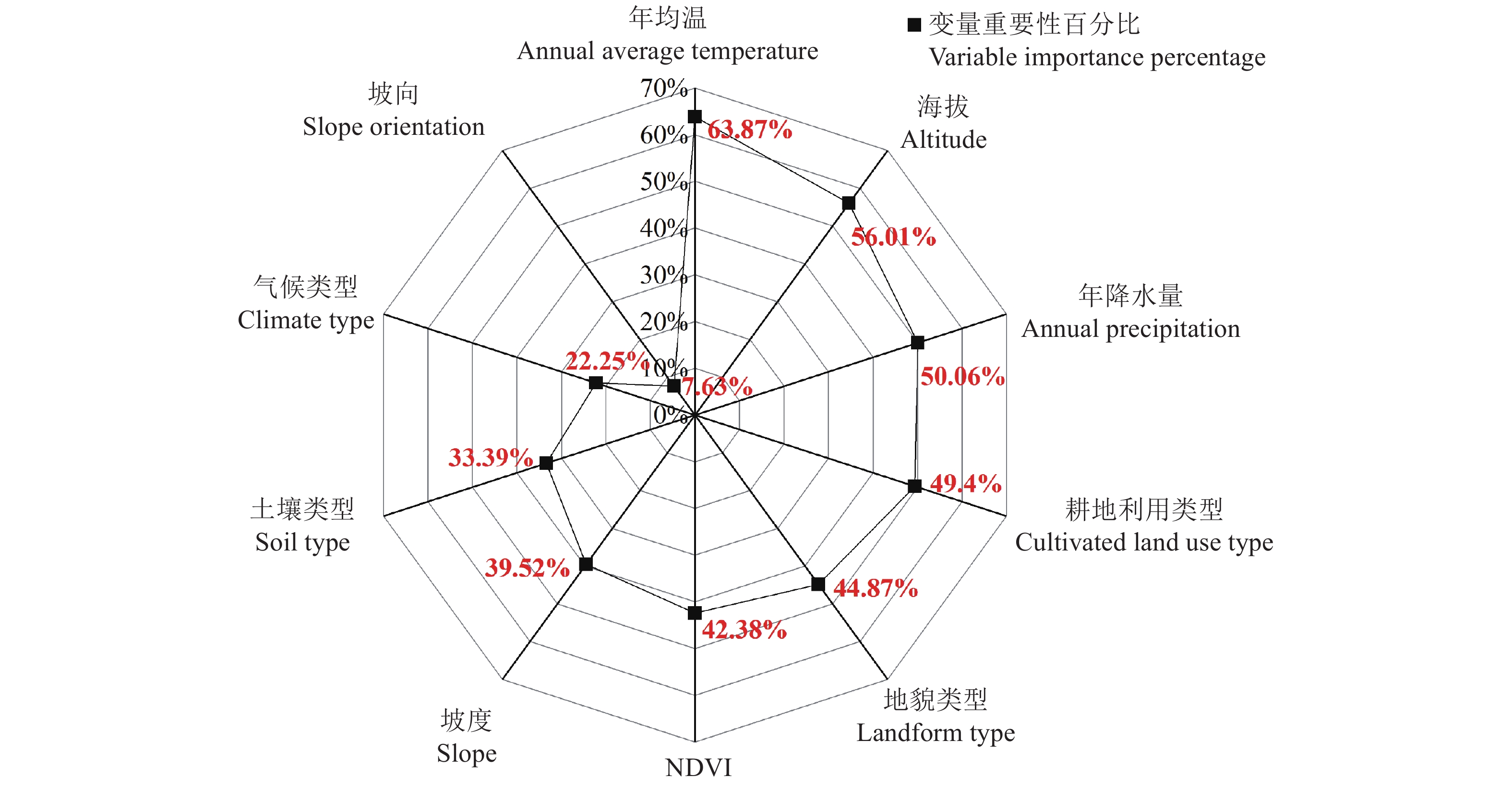
图 3 基于随机森林模型的各因素重要性雷达图
Figure 3. Radar diagram of the importance of various factors based on random forest model
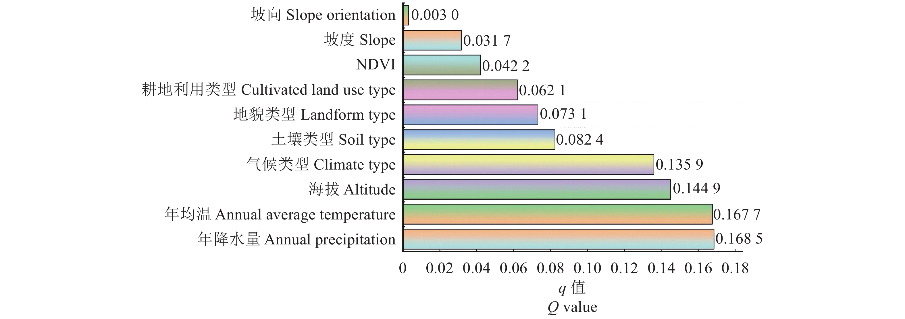
图 4 土壤有机碳含量影响因素因子探测结果
Figure 4. Detection results of factors affecting soil organic carbon content

图 5 土壤有机碳含量影响因素交互作用探测结果热力图
Figure 5. Heat map of the interaction detection results of factors affecting soil organic carbon content
表 1 各连续性因素与土壤有机碳相关分析
Table 1. Correlation analysis between various continuity factors and soil organic carbon
指标
Index土壤有机碳
Soil organic carbon年均温
Annual average temperature年降水量
Annual precipitation坡度
Slope坡向
Slope orientation海拔
Altitude归一化植被指数
NDVI土壤有机碳 Soil organic carbon 1 年均温 Annual average temperature −0.333** 1 年降水量 Annual precipitation 0.380** −0.878** 1 坡度 Slope 0.138** −0.404** 0.387** 1 坡向 Slope orientation −0.044** 0.041** −0.062** −0.133** 1 海拔 Altitude 0.284** −0.868** 0.703** 0.477** 0.062** 1 归一化植被指数 NDVI 0.134** −0.398** 0.391** 0.381** −0.129** 0.317** 1 **表示在P <0.01级别,相关性显著。
** indicates a significant correlation at the P <0.01 level. 下载: 导出CSV
表 3 气候因素对土壤有机碳的影响
Table 3. Impact of climate factors on soil organic carbon
指标
Index等级
Grade样点数量
Number of sample points土壤有机碳
Soil organic carbon/(g·kg−1)标准差
Standard deviation/
(g·kg−1)变异系数
Coefficient of
variation /%最小值
Minimum value最大值
Maximum value平均值
Average value年均温
Annual average temperature / ℃10.00≤年均温<17.16 3337 0.17 50.69 17.74 7.35 41.43 17.16≤年均温<17.95 2934 1.28 43.44 17.41 5.59 32.10 17.95≤年均温<18.73 5883 1.39 43.15 17.46 5.55 31.79 18.73≤年均温≤19.51 5857 0.12 67.28 17.07 6.16 36.09 19.51≤年均温≤20.29 4838 0.58 43.85 16.66 6.04 36.25 20.29≤年均温≤21.08 5428 0.19 37.12 11.79 5.48 46.48 21.08<年均温 3082 0.20 32.89 10.57 4.99 47.21
年降水量
Annual precipitation /mm1041≤年降水量<1232 5598 0.19 35.50 10.56 4.50 42.61 1232≤年降水量<1338 3720 0.58 62.93 13.64 5.87 43.04 1338≤年降水量<1438 5165 0.12 41.76 16.61 5.77 34.74 1438≤年降水量<1531 6552 1.16 43.85 17.06 5.56 32.59 1531≤年降水量<1644 8094 0.17 67.28 17.69 6.14 34.71 1644≤年降水量<1848 2230 2.38 50.69 17.70 8.02 45.31 气候类型
Climate type中亚热带
Middle subtropical zone21274 0.17 67.28 17.27 6.14 35.56 南亚热带
South subtropical zone10085 0.12 39.61 12.17 5.73 47.08
下载: 导出CSV
表 4 不同土壤类型、耕地利用和地貌类型下的土壤有机碳分布
Table 4. Effects of different soil types, cultivated land Use, and landform types on soil organic carbon
指标
Index类型
Type样点数量
Number of
sample points土壤有机碳
Soil organic carbon/(g·kg−1)标准差
Standard deviation/
(g·kg−1)变异系数
Coefficient of
variation /%最小值
Minimum value最大值
Maximum value平均值
Average value土壤类型
Soil type水稻土
Paddy soil27997 0.12 67.28 16.16 6.28 39.86 赤红壤
Lateritic red soil1831 0.58 30.80 9.72 4.72 48.56 红壤
Red earth912 1.22 43.85 15.68 6.56 41.84 风砂土
Aeolian sandy soil225 0.58 21.27 5.31 3.56 67.04 滨海盐土
Coastal saline soil175 0.99 27.20 7.91 5.10 64.48 潮土
Tidal soil108 1.80 30.97 11.56 5.55 48.01 黄壤
Yellow soil79 3.60 49.36 17.06 8.96 52.52 紫色土
Purple soil32 6.90 31.15 15.92 5.19 32.60 耕地利用类型
Cultivated land use type灌溉水田
Irrigated paddy fields23936 0.12 67.28 16.21 6.30 38.86 旱地
Dry land3434 0.58 50.69 11.64 6.58 56.53 望天田
Non-irrigated paddy field3288 0.17 42.92 16.57 5.75 34.70 水浇地
Irrigated land552 1.39 38.80 10.74 5.58 51.96 菜地
Vegetable field149 1.69 34.80 11.35 6.42 56.56 地貌类型
Landform type平原台地
Plain platform6942 0.19 50.11 12.36 6.44 52.10 丘陵
Hill8377 0.45 67.28 16.46 6.44 39.13 小起伏山地
Small undulating mountains14921 0.12 62.93 16.63 6.04 36.32 中起伏山地
Medium undulating mountain1119 1.39 38.34 16.39 5.74 35.02
下载: 导出CSV
表 2 不同影响因子下的福建省耕地土壤有机碳含量分级
Table 2. Classification of soil organic carbon content in cultivated land of Fujian Province under different influencing factors
分级分类
Graded
classification年均温
Annual
average
temperature/
℃年降水量
Annual
precipitation/
mm坡度
Slope/°坡向
Slope
orientation/
°海拔
Altitude/
m归一化
植被指数
NDVI气候类型
Climate
type地貌类型
Landform
type耕地利用类型
Cultivated land
use type土壤类型
Soil
type1 10.00~17.16 1041~1232 0~3 −1~2 1~112 −1~−0.09 中亚热带
Middle
subtropical zone平原台地
Plain platform灌溉水田
Irrigated
paddy fields水稻土
Paddy
soil2 17.16~17.95 1232~1338 3~5 2~6 112~244 −0.09~0.13 南亚热带
South
subtropical zone丘陵
Hill旱地
Dry land赤红壤
Lateritic
red soil3 17.95~18.73 1338~1438 5~8 6~18 244~376 0.13~0.35 小起伏山地
Small undulating
mountains望天田
Non-irrigated
paddy field红壤
Red earth4 18.73~19.51 1438~1531 8~12 18~50 376~508 0.35~0.57 中起伏山地
Medium undulating
mountain水浇地
Irrigated
land风砂土
Aeolian sandy soil5 19.51~20.29 1531~1644 12~17 50~134 508~639 0.57~1 大起伏山地
Great undulating
mountains菜地
Vegetable
field滨海盐土
Coastal saline
soil6 20.29~21.08 1644~1848 17~60 134~360 639~1348 潮土
Tidal
soil7 >21.08 黄壤
Yellow
soil8 紫色土
Purple
soil9 石灰土
Limestone
soil根据最优参数地理探测器计算结果,年均温、海拔和NDVI采用标准差分类法,分为7类、6类和5类;年降水量采用自然间距分类法,分为6类;坡度采用分位数分类法,分为6类;坡向采用几何间隔分类法,分为6类。
According to calculation results of the optimal geographic detector parameters, annual average temperature, altitude, and NDVI are classified using standard deviation classification method, which is divided into 7 categories, 6 categories, and 5 categories; Annual precipitation is classified into 6 categories using natural interval classification method; Slope is classified into 6 categories using quantile classification method; Slope orientation adopts geometric interval classification method, which is divided into 6 categories.
下载: 导出CSV
表 5 地形因素对土壤有机碳的影响
Table 5. Impact of terrain factors on soil organic carbon
指标
Index等级
Grade样点数量
Number of sample points/个土壤有机碳
Soil organic carbon/g·kg−1标准差
Standard
deviation/g·kg−1变异系数
Coefficient of
variation/%最小值
Minimum value最大值
Maximum value平均值
Average value坡度
Slope/°0≤坡度 Slope <3 5243 0.41 67.28 13.60 6.52 47.94 3≤坡度 Slope <5 5218 0.19 43.85 14.57 6.77 46.46 5≤坡度 Slope <8 5213 0.58 49.88 15.93 6.54 41.05 8≤坡度 Slope <12 5217 0.93 45.19 16.41 6.22 37.90 12≤坡度 Slope <17 5241 1.39 49.36 16.69 6.06 36.31 17≤坡度 Slope≤60 5227 0.12 62.93 16.58 6.04 36.43 坡向
Slope orientation /°−1≤坡向 Slope orientation <2 391 1.16 50.69 14.54 6.84 47.04 2≤坡向 Slope orientation <6 309 2.73 38.74 16.21 6.20 38.25 6≤坡向 Slope orientation <18 956 1.10 41.18 15.31 6.18 40.37 18≤坡向 Slope orientation <50 3376 0.99 50.11 16.10 6.56 40.75 50≤坡向 Slope orientation≤134 9924 0.20 62.93 15.99 6.43 40.21 134≤坡向 Slope orientation≤360 16403 0.12 67.28 15.35 6.47 42.15 海拔 Altitude/m 1≤海拔 Altitude<112 9598 0.19 43.85 11.87 5.73 48.27 112≤海拔 Altitude<244 5080 1.16 67.28 17.41 6.29 36.13 244≤海拔 Altitude<376 5341 1.28 62.93 17.33 5.51 31.79 376≤海拔 Altitude<508 4197 0.12 43.44 16.87 5.56 32.96 508≤海拔 Altitude<639 2932 0.17 42.75 17.20 5.75 33.43 639≤海拔 Altitude≤1348 4211 2.20 50.69 17.56 7.07 40.26
下载: 导出CSV
-
[1] 王兴, 钟泽坤, 王佳懿, 等. 黄土高原撂荒草地土壤碳库对两年增温增雨的响应 [J]. 土壤学报, 2023, 60(2):523−534.WANG X, ZHONG Z K, WANG J Y, et al. Responses of soil carbon pool of abandoned grassland on the Loess Plateau to two-years warming and increased precipitation [J]. Acta Pedologica Sinica, 2023, 60(2): 523−534. (in Chinese) [2] 李园园, 王蕾, 刘琪璟, 等. 新疆喀纳斯自然保护区森林碳储量及碳密度变化 [J]. 干旱区研究, 2019, 36(5):1136−1145.LI Y Y, WANG L, LIU Q J, et al. Changes of carbon storage and carbon density of forests in the kanas national nature reserve, Xinjiang [J]. Arid Zone Research, 2019, 36(5): 1136−1145. (in Chinese) [3] 张维理, KOLBE H, 张认连. 土壤有机碳作用及转化机制研究进展 [J]. 中国农业科学, 2020, 53(2):317−331. doi: 10.3864/j.issn.0578-1752.2020.02.007ZHANG W L, KOLBE H, ZHANG R L. Research progress of SOC functions and transformation mechanisms [J]. Scientia Agricultura Sinica, 2020, 53(2): 317−331. (in Chinese) doi: 10.3864/j.issn.0578-1752.2020.02.007 [4] WANG S, ZHUANG Q L, JIA S H, et al. Spatial variations of soil organic carbon stocks in a coastal hilly area of China [J]. Geoderma, 2018, 314: 8−19. doi: 10.1016/j.geoderma.2017.10.052 [5] LI Q Q, ZHANG H, JIANG X Y, et al. Spatially distributed modeling of soil organic carbon across China with improved accuracy [J]. Journal of Advances in Modeling Earth Systems, 2017, 9(2): 1167−1185. doi: 10.1002/2016MS000827 [6] TENG M J, ZENG L X, XIAO W F, et al. Spatial variability of soil organic carbon in Three Gorges Reservoir area, China [J]. The Science of the Total Environment, 2017, 599/600: 1308−1316. doi: 10.1016/j.scitotenv.2017.05.085 [7] MA H H, PENG M, YANG Z, et al. Spatial distribution and driving factors of soil organic carbon in the Northeast China Plain: Insights from latest monitoring data [J]. The Science of the Total Environment, 2024, 911: 168602. doi: 10.1016/j.scitotenv.2023.168602 [8] 李艾雯, 冉敏, 宋靓颖, 等. 四川盆地耕地表层土壤有机碳含量空间分布特征及其影响因素 [J]. 长江流域资源与环境, 2023, 32(5):1102−1112.LI A W, RAN M, SONG L Y, et al. Spatial distribution characteristics and influencing factors of cropland topsoil organic carbon content in the Sichuan Basin [J]. Resources and Environment in the Yangtze Basin, 2023, 32(5): 1102−1112. (in Chinese) [9] 张勇, 史学正, 赵永存, 等. 滇黔桂地区土壤有机碳储量与影响因素研究 [J]. 环境科学, 2008, 29(8):2314−2319.ZHANG Y, SHI X Z, ZHAO Y C, et al. Estimates and affecting factors of soil organic carbon storages in Yunnan-Guizhou-guangxi region of China [J]. Environmental Science, 2008, 29(8): 2314−2319. (in Chinese) [10] SUN T, TONG W J, CHANG N J, et al. Estimation of soil organic carbon stock and its controlling factors in cropland of Yunnan Province, China [J]. Journal of Integrative Agriculture, 2022, 21(5): 1475−1487. doi: 10.1016/S2095-3119(21)63620-1 [11] LUO Y L, WANG K, LI H X, et al. Application of a combinatorial approach for soil organic carbon mapping in hills [J]. Journal of Environmental Management, 2021, 300: 113718. doi: 10.1016/j.jenvman.2021.113718 [12] BAI Y X, ZHOU Y C. The main factors controlling spatial variability of soil organic carbon in a small Karst watershed, Guizhou Province, China [J]. Geoderma, 2020, 357: 113938. doi: 10.1016/j.geoderma.2019.113938 [13] 程金, 黄文卿, 张世昌, 等. 福建省表层土壤有机碳密度空间分布及影响因素分析 [J]. 农业资源与环境学报, 2023, 40(4):805−816.CHENG J, HUANG W Q, ZHANG S C, et al. Spatial distribution and influencing factors of topsoil organic carbon density in Fujian Province, China [J]. Journal of Agricultural Resources and Environment, 2023, 40(4): 805−816. (in Chinese) [14] ZHAO B H, LI Z B, LI P, et al. Spatial distribution of soil organic carbon and its influencing factors under the condition of ecological construction in a hilly-gully watershed of the Loess Plateau, China [J]. Geoderma, 2017, 296: 10−17. doi: 10.1016/j.geoderma.2017.02.010 [15] 林景亮. 福建土壤[M]. 福州: 福建科学技术出版社, 1991. [16] 国土资源部. 国土资源部关于印发试行《土地分类》的通知[L]. 2001-08-21.Ministry of Land and Resources. Notice of the Ministry of Land and Resources on Issuing the Trial Implementation of Land Classification [L]. 2001-08-21. [17] 陈中星, 张楠, 张黎明, 等. 福建省土壤有机碳储量估算的尺度效应研究 [J]. 土壤学报, 2018, 55(3):606−619.CHEN Z X, ZHANG N, ZHANG L M, et al. Scale effects of estimation of soil organic carbon storage in Fujian Province, China [J]. Acta Pedologica Sinica, 2018, 55(3): 606−619. (in Chinese) [18] 姚彩燕, 刘绍贵, 乔婷, 等. 基于时空变异的旱地土壤有机碳高效采样策略研究 [J]. 土壤学报, 2021, 58(3):638−648.YAO C Y, LIU S G, QIAO T, et al. Strategy for efficient sampling of upland soil based on spatiotemporal variation of the soil [J]. Acta Pedologica Sinica, 2021, 58(3): 638−648. (in Chinese) [19] PENG S Z, DING Y X, LIU W Z, et al. 1 km monthly temperature and precipitation dataset for China from 1901 to 2017 [J]. Earth System Science Data, 2019, 11(4): 1931−1946. doi: 10.5194/essd-11-1931-2019 [20] 金林, 李研. 几种相关系数辨析及其在R语言中的实现 [J]. 统计与信息论坛, 2019, 34(4):3−11.JIN L, LI Y. Discrimination of several correlation coefficients and their implementation in R software [J]. Statistics & Information Forum, 2019, 34(4): 3−11. (in Chinese) [21] BREIMAN L. Random forests [J]. Machine Learning, 2001, 45: 5−32. doi: 10.1023/A:1010933404324 [22] LIAW A, WIENER M. Classification and regression by randomForest [J]. R news, 2002, 2(3): 18−22. [23] WANG J F, LI X H, CHRISTAKOS G, et al. Geographical detectors-based health risk assessment and its application in the neural tube defects study of the Heshun region, China [J]. International Journal of Geographical Information Science, 2010, 24(1): 107−127. doi: 10.1080/13658810802443457 [24] 王劲峰, 徐成东. 地理探测器: 原理与展望 [J]. 地理学报, 2017, 72(1):116−134.WANG J F, XU C D. Geodetector: Principle and prospective [J]. Acta Geographica Sinica, 2017, 72(1): 116−134. (in Chinese) [25] SONG Y Z, WANG J F, GE Y, et al. An optimal parameters-based geographical detector model enhances geographic characteristics of explanatory variables for spatial heterogeneity analysis: Cases with different types of spatial data [J]. GIScience & Remote Sensing, 2020, 57(5): 593−610. [26] LI Q Q, YUE T X, WANG C Q, et al. Spatially distributed modeling of soil organic matter across China: An application of artificial neural network approach [J]. CATENA, 2013, 104: 210−218. doi: 10.1016/j.catena.2012.11.012 [27] JIANG R, WU P, SONG Y Z, et al. Factors influencing the adoption of renewable energy in the U. S. residential sector: An optimal parameters-based geographical detector approach [J]. Renewable Energy, 2022, 201: 450−461. doi: 10.1016/j.renene.2022.09.084 [28] JENKINSON D S, ADAMS D E, WILD A. Model estimates of CO2 emissions from soil in response to global warming [J]. Nature, 1991, 351: 304−306. doi: 10.1038/351304a0 [29] REYNA-BOWEN L, LASOTA J, VERA-MONTENEGRO L, et al. Distribution and factors influencing organic carbon stock in mountain soils in Babia góra National Park, Poland [J]. Applied Sciences, 2019, 9(15): 3070. doi: 10.3390/app9153070 [30] DAVIDSON E A, JANSSENS I A. Temperature sensitivity of soil carbon decomposition and feedbacks to climate change [J]. Nature, 2006, 440: 165−173. doi: 10.1038/nature04514 [31] 丰思捷, 赵艳云, 李元恒, 等. 内蒙古典型草原表层土壤有机碳储量差异及影响因素 [J]. 中国草地学报, 2019, 41(2):116−120.FENG S J, ZHAO Y Y, LI Y H, et al. The differences and influencing factors of topsoil organic carbon storage in typical steppe of inner Mongolia [J]. Chinese Journal of Grassland, 2019, 41(2): 116−120. (in Chinese) [32] 周晓宇, 张称意, 郭广芬. 气候变化对森林土壤有机碳贮藏影响的研究进展 [J]. 应用生态学报, 2010, 21(7):1867−1874.ZHOU X Y, ZHANG C Y, GUO G F. Effects of climate change on forest soil organic carbon storage: A review [J]. Chinese Journal of Applied Ecology, 2010, 21(7): 1867−1874. (in Chinese) [33] ZHANG X F, ADAMOWSKI J F, LIU C F, et al. Which slope aspect and gradient provides the best afforestation-driven soil carbon sequestration on the China’s Loess Plateau? [J]. Ecological Engineering, 2020, 147: 105782. doi: 10.1016/j.ecoleng.2020.105782 [34] 丁金梅, 王维珍, 米文宝, 等. 宁夏草地土壤有机碳空间特征及其影响因素 [J]. 生态学报, 2023, 43(5):1913−1922.DING J M, WANG W Z, MI W B, et al. Spatial characteristics of soil organic carbon in grassland of Ningxia and its influencing factors [J]. Acta Ecologica Sinica, 2023, 43(5): 1913−1922. (in Chinese) -

 点击查看大图
计量
- 文章访问数: 18
- HTML全文浏览量: 11
- PDF下载量: 0
- 被引次数: 0
