Information Gathering on Rice Planting Area Using GF-1/WFV EVI Time Series Technology
-
摘要: 随着国产高分系列卫星的发射,国产高分辨率遥感影像在作物种植面积提取方面逐渐得到了应用,但目前仅有少量基于高分一号(GF-1)卫星影像归一化植被指数(Normalized Difference Vegetation Index,NDVI)进行作物分类或遥感估产的研究。本文针对NDVI指数在南方多植被覆盖区域易饱和及不敏感的缺陷,利用在NDVI基础上改进的增强型植被指数(Enhanced Vegetation Index,EVI),首次提出基于GF-1卫星16 m宽覆盖影像(Wide Field of View,WFV)EVI时间序列的水稻种植面积提取方法。选取四川省乐至县为研究区域,获取覆盖整个水稻生长周期的GF-1/WFV影像数据,构建EVI时间序列,并分析水稻不同生长期的EVI曲线特征。利用时间序列谐波分析法(Harmonic Analysis of Time Series,HANTS)对EVI时间序列进行平滑处理,尽可能减少噪声影响,使EVI时间序列能够更好地反应水稻及其他植被或非植被随时间的变化规律;根据水稻和其他植被及非植被的EVI曲线特征差异构建水稻种植面积提取决策树模型,对水稻种植面积进行准确提取。通过与同期地理国情监测成果的对比,本研究方法提取的水稻种植面积和精度都较高,表明该方法对于提取水稻种植面积效果良好。研究表明,相对于以往用中低分辨率卫星影像进行作物种植结构提取,GF1/WFV影像在南方较破碎的水稻种植面积提取方面应用效果良好,GF-1卫星影像在农业遥感领域具备很大的应用潜力。Abstract: With the successful launching of high-resolution satellites of the China High-Resolution Earth Observation System, the remote sensing images obtained will be increasingly applied for information gathering on crop planting. At present, limited studies were conducted on crop classification and yield estimation using the GF-1 satellite images based on the Normalized Difference Vegetation Index(NDVI). The NDVI transmissions tended to be over-crowded and low in resolution for the southern part of China due to the high vegetation growth in the areas.The proposed method utilized the improved Enhanced Vegetation Index(EVI) time series of GF-1 Wide Field View (WFV) images to overcome the deficiency. Lezhi county in Sichuan province was chosen for our testing.The GF-1/WFV images encompassing the entire rice growth period were acquired to construct the EVI time series.The characteristic EVI curves were obtained for the rice crops covering different growth stages. The Harmonic Analysis of Time Series(HANTS) method was adopted to smooth the EVI time series and maximally reduce the noise to enable reliable reflection of the dynamic changing patterns of rice and other crops or non-crop objects. Thereby, with the aid of the decision tree model, the rice planting area and other relevant information could be extracted. Comparing the results with what was obtained by the geographical conditions monitoring during a same time frame, the current method was considered accurate and precise. The GF-1/WFV images were particularly superior to the moderate or low resolution satellite images for gathering information on rice planting area in the regions where rice fields are scattered widely. The GF-1 technology was believed to represent a significant potential for applications in the field of agricultural remote sensing.
-
Keywords:
- GF1 /
- EVI /
- time series /
- rice /
- area /
- geographical conditions monitoring
-
水稻是中国的主栽高产作物,水稻种植的空间分布在农业生产管理与农业政策制定方面具有十分重要的作用,对确保我国乃至世界粮食安全都具有重要意义[1-3]。美国是最早开始利用遥感技术开展作物面积监测的国家,其获取的数据产品对于美国农业生产及相关科学研究应用起到了重要作用,产生了巨大的经济社会效益[4-6]。中国从“六五”计划开始开展农作物遥感估产研究,早期主要采用中低分辨率的气象卫星NOAA/AVHRR(Advanced very high resolution radiometer)等遥感数据进行大面积作物长势监测和产量估算[7-8],但气象卫星数据的低空间分辨率使得作物遥感监测效果不甚理想,近年来逐渐被空间分辨率相对较高的中分辨率成像光谱仪(Moderate Resolution Imaging Spectroradiometer,MODIS)数据代替[9-11]。中高分辨率遥感数据如美国陆地卫星(Landsat)、中巴地球资源卫星(China & Brazil Earth Resource Satellite,CBERS)由于重访周期长,难以实现作物连续监测,也限制了其在作物面积提取方面的应用。高分辨率遥感数据QuickBird、SPOT等,一般精度较高,但时间分辨率难以实现持续监测且费用昂贵。随着高分系列卫星陆续发射,国产高分辨率遥感数据在作物面积提取和长势监测等方面得到了一定的应用,但是目前用国产高分数据进行农作物种植面积提取只有较少的尝试[12-14]。
四川平原位于我国水稻优势区,但地形复杂、气候多云雾,而且水稻种植结构较破碎,使得水稻种植面积提取具有一定难度。目前利用GF-1数据进行作物种植结构提取的研究多是基于NDVI指数,NDVI与植被覆盖度呈现明显的正相关,是长期以来最常用的植被指数[15],被广泛应用于植物信息提取研究;然而当植被覆盖率高到一定程度时NDVI指数会趋于饱和,表现出不敏感性[16]。本研究利用EVI指数,基于多时相GF-1/WFV遥感数据开展水稻种植面积提取方法研究,并利用地理国情监测数据成果进行验证,旨在寻求一种快速、准确提取水稻种植面积的方法,为推动GF-1数据的应用提供基础。
1. 材料与方法
1.1 研究区概况
乐至县是四川省资阳市下辖县,介于北纬30°0′2″~30°30′4″、东经104°45′2″~105°15′2″,属于亚热带季风气候,四季分明、雨量充沛、云雾多、湿度大,日均气温16.7℃,年均日照1 330 h,年均降水量900 mm。乐至县地势西北略高于东南,中部沱江、涪江分水线纵贯南北,县内大小河流20条,为川中著名的河源地。地形以平原浅丘为主,土地肥沃,属于四川省农产品主产区之一,主要粮油作物以水稻、小麦、玉米、大豆和油菜为主。乐至县水稻以一季稻为主,每年5月为秧苗期,6~7月中旬为分蘖期,7月下旬至8月中下旬为抽穗期,9月为结实期,9月底至10月收割。
1.2 数据及预处理
1.2.1 数据源
GF-1卫星是国家高分辨率对地观测系统重大专项天基系统中的首发星,于2013年4月发射,搭载了两台2 m分辨率全色/8 m分辨率多光谱相机和四台16 m分辨率多光谱相机,重访周期4 d。其中4台WFV相机组合扫描宽度为800 km,包括蓝(0.45 ~ 0.52 μm)、绿(0.52 ~ 0.59 μm)、红(0.63 ~ 0.69 μm)、近红外(0.77 ~ 0.89 μm)4个波段。
GF-1/WFV影像可从中国资源卫星应用中心申请下载(http://www.cresda.com/CN/),本文选取2016年3 ~ 11月共6个时辰的GF-1/WFV影像,在时间跨度上覆盖了整个水稻生长周期。影像具体信息见表 1,其中8月份的影像由两景影像共同覆盖,所以共有7景影像。
表 1 GF-1/WFV影像信息Table 1. Information of GF-1/WFV images序号 传感器类型 中心经、纬度 获取时间/(年-月-日) 1 WFV4 104.3°E, 30.1°N 2016-03-18 2 WFV1 104.9°E, 29.6°N 2016-05-09 3 WFV4 104.1°E, 30.2°N 2016-06-16 4 WFV2 105.7°E, 31.0°N 2016-08-24 5 WFV2 105.3°E, 29.3°N 2016-08-24 6 WFV4 105.1°E, 30.2°N 2016-09-10 7 WFV1 105.4°E, 29.6°N 2016-11-26 此外,收集乐至县2016年地理国情监测成果数据、行政区划数据以及5 m分辨率的DEM数据等辅助数据,其中地理国情监测成果数据主要用于感兴趣区域(Region Of Interest,ROI)选取及对本文研究结果进行验证,行政区划数据用于数据裁切,DEM数据用于影像几何校正及坡度数据计算等。
1.2.2 数据预处理
对遥感影像数据的预处理主要包括辐射定标、大气校正、几何校正、影像裁切。辐射定标是将影像记录的原始DN(Digital Number)值转换为大气外层表面反射率,辐射定标参数可以在中国资源卫星应用中心网站下载;大气校正将辐射亮度或者表面反射率转换为地表实际反射率,所需的波普响应函数也可以从中国资源卫星应用中心网站获取,利用ENVI 5.3的Flaash大气校正模块,消除大气散射、吸收、反射引起的误差。几何校正以精校正的Landsat 8 15 m分辨率全色影像作为参考,结合研究区域的DEM数据,通过采集控制点、区域网平差、正射校正等处理,得到乐至县正射影像。最后利用乐至县的行政区划对几何校正的影像进行裁切,其中8月份的两景影像需要先镶嵌再裁切。
1.3 水稻种植面积提取方法
1.3.1 EVI时间序列构建
(1) EVI时间序列计算:EVI是在NDVI基础上发展起来的植被指数,由Huete等[17-18]提出,计算公式如下:
EVI=2.5×(ρNIR−ρRED)/(L+ρNIR+C1ρRED−C2ρBLUE) (1) 式中,L为土壤条件参数,取值为1;C1为大气修正红光校正参数,取值为6;C2为大气修正蓝光校正参数,取值为7.5;ρNIR、ρRED、ρBLUE分别为近红外波段、红波段和蓝波段的反射率。
EVI指数通过引进蓝光波段解决了NDVI指数在高植被覆盖区域的饱和问题,同时对大气、气溶胶、土壤背景影响做了校正,提高了对高植被覆盖区的识别敏感性[19-21]。
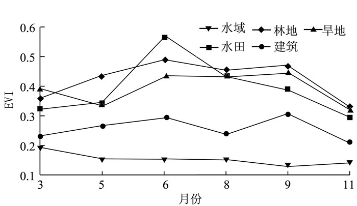
(2) EVI曲线分析:根据乐至县地理国情监测成果,在乐至县均匀选取水稻、旱地、林地、水域、建筑等5类地物的样本点,分别绘制20个ROI。利用ROI文件对每类地物各时相的EVI均值进行统计,得到5类地物样本点的EVI时间变化曲线,结果如图 1所示。从图中可以看出,植被与非植被的EVI曲线有明显差异,而不同植被的EVI曲线随时间变化的规律亦不相同。
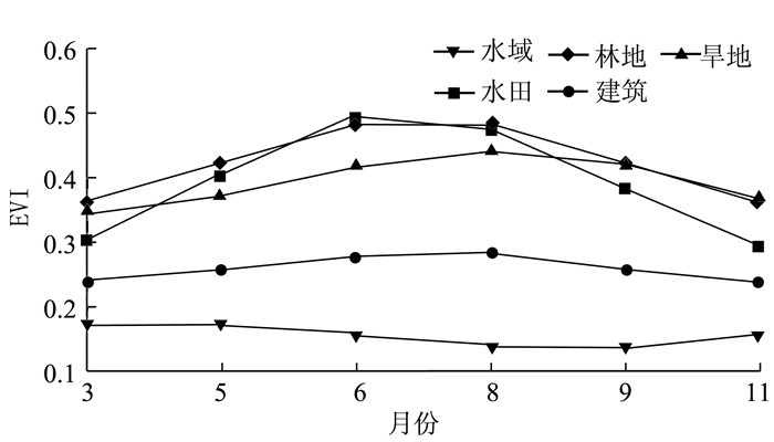
(3) EVI时间序列平滑处理:由于植被指数受到各种因素影响会出现异常,呈现不规则性,必然会影响分析结果。因此,有必要对EVI时间序列进行平滑处理以降低噪声、尽可能减少误差影响[22]。HANTS方法是常用的植被指数重建方法,充分考虑了植被生长周期性和数据本身的特点,能够很好地去除随机噪声和云雪影响,真实反映植被的周期性变化规律[23-24]。为更精确地获取水稻种植面积,本文选用HANTS方法对EVI时间序列数据进行处理,设置有效数据范围(Valid data range)为[-1, 1],拟合误差(Fitting error tolerance)为0.05,频率(Number of frequencies)为3,结果如图 2所示。通过图 1与图 2的对比可以发现,经过平滑处理后的EVI时间序列去掉了异常波动,更接近地物EVI指数的真实变化规律。
从图 2可以看出,水域和建筑等所代表的非植被,EVI指数在整个时间序列都较低,很容易和植被进行区分。水田和林地、旱地的EVI曲线重叠较大,3月份水稻还未插秧,EVI指数较低,而林地和旱地的EVI指数相对高一些;5月份水稻移栽至水田,EVI指数开始呈上升趋势,同时气温上升导致林地和旱地的EVI指数纷纷抬升,6月份达到峰值,并持续到8月份;9月份是水稻收获季节,水田的EVI指数呈下降趋势,然而此时林地和旱地的EVI指数下降较缓;11月份,水稻收割完毕,这时水田的EVI指数与林地和旱地有明显差异。因此可以综合利用不同月份的EVI指数变化特征来区分水田和林地、旱地等植被。
1.3.2 构建水稻种植面积提取模型
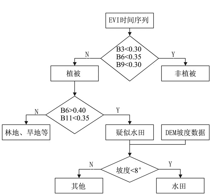
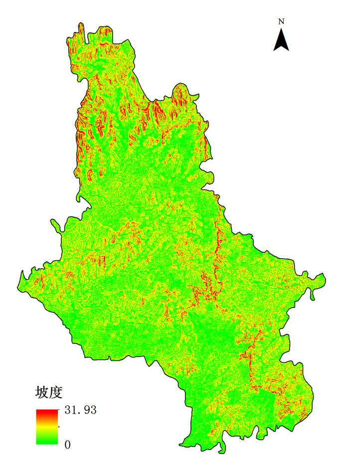
根据上一节的分析,可以根据EVI时间序列不同时相的特征构建水稻种植面积提取决策树模型,如图 3所示,其中B代表波段,后面的数字代表月份,如B3表示3月份的波段,B6表示6月份的波段,等等。首先区分植被与非植被,将EVI都小于0.3的划为非植被,否则为植被;为尽可能去除非植被的影响,将6月的EVI指数阈值设置为0.35。为区分水田与其他植被,根据水稻的物候特征,利用6月份生长旺季的EVI指数高和11月份收获后水田的EVI植被指数低这一反差来提取疑似水田,排除其他常绿植被;最后,考虑到水田必须分布在地势平坦的区域,而乐至县地形以平原浅丘为主,故需要增加地形约束以得到更加准确的结果。利用乐至县5 m分辨率数据生成坡度图,如图 4所示,将坡度图与地理国情监测得到的水田数据进行叠加,对重叠区域的坡度进行统计,发现水田分布区域的坡度不超过8°。利用这一特征,提取水田时结合DEM坡度数据,剔除坡度大于8°的区域以进一步排除常绿植被的影响。
2. 结果与分析
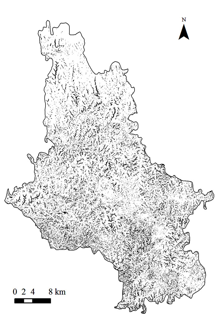
根据水稻种植面积提取模型得到的水稻种植空间分布如图 5所示,从乐至县的水稻空间分布来看,乐至县水稻种植较广,基本遍布整个县域。跟北方大块种植的作物相比,乐至县的水田地块比较零碎,受丘陵地形影响较大,总体沿着丘陵平缓地带分布。经统计得到乐至县2016年水稻种植面积为203.77 km2。
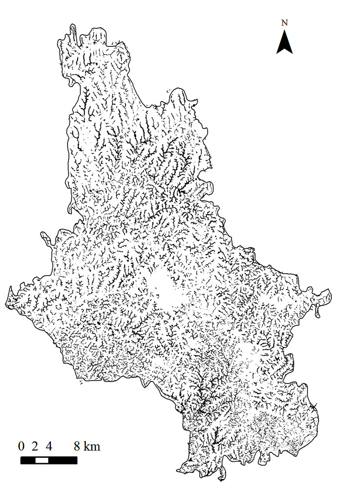
图 6是2016年地理国情监测成果中的水田数据。地理国情监测成果是经过高分辨率遥感影像判读和野外调查得到的,可以认为是比较可靠的参考数据。2016年地理国情监测成果中乐至县的水田图层面积统计为199.40 km2,与本研究提取结果相对误差仅为2.19%,总体一致性较好。从地理国情监测成果的乐至县水田图层中随机选取部分水稻样区进行精度分析,结果如表 2所示,水稻提取的总体精度为96.52%,Kappa系数为0.93,可见本研究方法提取的水稻种植面积结果比较可靠。
表 2 水稻提取精度评价Table 2. Precision of information extraction on rice planting area类别 水稻/% 非水稻/% 总体精度/% Kappa系数 水稻 96.73 3.77 96.52 0.93 非水稻 3.27 96.23 制图精度 96.73 96.23 用户精度 97.28 95.48 3. 讨论与结论
研究区域水稻为一季稻,根据本文提出的决策树模型剔除了林地、旱地等其他植被及非植被的影响,通过与地理国情监测成果对比,整体提取结果比较理想。本文方法充分利用了国产GF-1号高时间分辨率和适中的空间分辨率,获取了覆盖水稻整个生长周期的数据,并根据水稻不同生长期的EVI时间序列特征将水稻与其他植被或非植被区分开来,能够较准确地提取水稻面积,方法操作简便,易于推广。但本文方法也有不足之处,在中心城区也提取了部分水田,与实际不符,很可能是受到城区植被的影响。另外,对于南方比较破碎的种植结构,GF-1的空间分辨率尚显不足,若要得到更精确的结果,还需要更高分辨率的遥感影响数据支持。
本文利用覆盖水稻整个生长周期的GF-1/WFV影像,首次选取EVI植被指数构建水稻生长期的时间序列并用HANTS方法进行平滑处理,根据水稻生长期间的EVI曲线特征提出决策树模型对水田进行提取,结果表明GF-1/WFV影像的EVI植被指数对于提取南方破碎种植结构的作物面积效果良好,本文提取的水稻面积与地理国情监测成果相对误差仅为2.19%,总体精度为96.52%,Kappa系数为0.93,表明本文方法能够有效提取水稻种植面积,也证明了GF-1影像在作物种植结构提取方面具有广泛的应用潜力。
-
表 1 GF-1/WFV影像信息
Table 1 Information of GF-1/WFV images
序号 传感器类型 中心经、纬度 获取时间/(年-月-日) 1 WFV4 104.3°E, 30.1°N 2016-03-18 2 WFV1 104.9°E, 29.6°N 2016-05-09 3 WFV4 104.1°E, 30.2°N 2016-06-16 4 WFV2 105.7°E, 31.0°N 2016-08-24 5 WFV2 105.3°E, 29.3°N 2016-08-24 6 WFV4 105.1°E, 30.2°N 2016-09-10 7 WFV1 105.4°E, 29.6°N 2016-11-26 表 2 水稻提取精度评价
Table 2 Precision of information extraction on rice planting area
类别 水稻/% 非水稻/% 总体精度/% Kappa系数 水稻 96.73 3.77 96.52 0.93 非水稻 3.27 96.23 制图精度 96.73 96.23 用户精度 97.28 95.48 -
[1] 陈仲新, 任建强, 唐华俊, 等.农业遥感研究应用进展与展望[J].遥感学报, 2016(5):748-767. http://www.cnki.com.cn/Article/CJFDTOTAL-WHCH201405001.htm [2] 吴炳方.全国农情监测与估产的运行化遥感方法[J].地理学报, 2000(1):25-35. DOI: 10.11821/xb200001003 [3] 杨晓光, 刘志娟, 陈阜.全球气候变暖对中国种植制度可能影响Ⅰ.气候变暖对中国种植制度北界和粮食产量可能影响的分析[J].中国农业科学, 2010, 43(2):329-336. http://www.cnki.com.cn/Article/CJFDTOTAL-ZNYK201002015.htm [4] BENEDETTI R, ROSSINI P. On the use of NDVI profiles as a tool for agricultural statistics:The case study of wheat yield estimate and forecast in Emilia Romagna[J]. Remote sensing of environment, 1993, 45(3):311-326. DOI: 10.1016/0034-4257(93)90113-C
[5] MACDONALD R B, HALL F G. Global Crop Forecasting[J]. Science, 1980, 208(4445):670-679. DOI: 10.1126/science.208.4445.670
[6] CARLSON T N, RIPLEY D A. On the relation between NDVI, fractional vegetation cover, and leaf area index[J]. Remote sensing of environment, 1997, 62(3):241-252. DOI: 10.1016/S0034-4257(97)00104-1
[7] 王延颐, MALINGREAU J P.应用NOAA-AVHRR对江苏省作物进行监测的可行性研究[J].环境遥感, 1990, 5(3):221-227. http://www.oalib.com/paper/4184007 [8] 肖乾广.用NOAA气象卫星AVHRR的定量资料计算冬小麦种植面积的两种方法[J].环境遥感, 1989, 4(3):191-196. http://www.cnki.com.cn/Article/CJFDTotal-ZGNY199204005.htm [9] 彭代亮. 基于统计与MODIS数据的水稻遥感估产方法研究[D]. 杭州: 浙江大学, 2009. http://www.wanfangdata.com.cn/details/detail.do?_type=degree&id=Y1647020 [10] 张军龙. 基于MODIS_EVI重庆水稻估产[D]. 重庆: 重庆师范大学, 2014. http://cdmd.cnki.com.cn/Article/CDMD-10637-1014357388.htm [11] 王长耀.林文鹏.基于MODIS EVI的冬小麦产量遥感预测研究[J].农业工程学报, 2005, 21(10):90-94. DOI: 10.3321/j.issn:1002-6819.2005.10.021 [12] 丁春雨, 马冠南, 张晓娇, 等.利用高分一号影像提取水稻种植面积方法研究——以长春榆树市为例[J].农业与技术, 2016, 36(7):1-4, 19. http://d.old.wanfangdata.com.cn/Periodical/nyyjs201607002 [13] 贾玉秋, 李冰, 程永政, 等.基于GF-1与Landsat-8多光谱遥感影像的玉米LAI反演比较[J].农业工程学报, 2015, 31(9):173-179. DOI: 10.11975/j.issn.1002-6819.2015.09.027 [14] 杨闫君, 占玉林, 田庆久, 等.基于GF-1/WFVNDVI时间序列数据的作物分类[J].农业工程学报, 2015, 31(24):155-161. DOI: 10.11975/j.issn.1002-6819.2015.24.024 [15] ROUSE J W, HAAS R H, SCHELL J A, et al. Monitoring vegetation systems in the Great Plains with ERTS[C]. //NASA. Goddard Space Flight Center Third Earth Resources Technology Satellite (ERTS) symposium, 1974(1), Sect. A: 309-317.
[16] 王正兴, 刘闯, ALFREDO H.植被指数研究进展:从AVHRR-NDVI到MODIS-EVI[J].生态学报, 2003, 23(5):979-987. http://www.cnki.com.cn/Article/CJFDTOTAL-STXB200305019.htm [17] HUETE A R, LIU H Q, BATCHILY K, et al. A comparison of vegetation indices over a global set of TM images for EOS-MODIS[J]. Remote sensing of environment, 1997, 59(3):440-451. DOI: 10.1016/S0034-4257(96)00112-5
[18] LIU H Q, HUETE A R. A feedback based modification of the NDVI to minimize canopy background and atmospheric noise[J]. IEEE Transactions on Geoscience and Remote Sensing, 1995, 33(2):457-465. DOI: 10.1109/36.377946
[19] 李文梅, 覃志豪, 李文娟, 等. MODIS NDVI与MODIS EVI的比较分析[J].遥感信息, 2010(6):73-78. http://www.wanfangdata.com.cn/details/detail.do?_type=perio&id=ygxx201006016 [20] 王正兴, 刘闯, 陈文波, 等. MODIS增强型植被指数EVI与NDVI初步比较[J].武汉大学学报(信息科学版), 2006, 31(5):407-410, 427. http://www.cnki.com.cn/Article/CJFDTotal-WHCH200605008.htm [21] CHEN P Y, FEDOSEJEVS G, TISCAREÑO-LÓPEZ M, et al. Assessment of MODIS-EVI, MODIS-NDVI and VEGETATION-NDVI composite data using agricultural measurements:an example at corn fields in western Mexico[J]. Environmental monitoring and assessment, 2006, 119(1-3):69-82. DOI: 10.1007/s10661-005-9006-7
[22] ZHOU J, JIA L, MENENTI M.Reconstruction of global MODIS NDVI time series:Performance of Harmonic ANalysis of Time Series(HANTS)[J]. Remote sensing of environment, 2015, 163(Suppl C):217-228. https://www.deepdyve.com/lp/elsevier/reconstruction-of-global-modis-ndvi-time-series-performance-of-bll2kgUmg0
[23] 侯光雷, 张洪岩, 王野乔, 等.基于时间序列谐波分析的东北地区耕地资源提取[J].自然资源学报, 2010, 25(9):1607-1617. DOI: 10.11849/zrzyxb.2010.09.020 [24] 梁守真, 邢前国, 施平, 等.山东省典型地表覆被NDVI时间序列谐波分析[J].生态学杂志, 2011, 30(1):59-65. http://www.oalib.com/paper/4972647 -
期刊类型引用(12)
1. 秦金凤,郑欣飞,包云轩,苏钰格,陆明红,曾娟,张熠玚. 褐飞虱春季境外虫源地水稻物候期对我国华南和西南稻区首迁峰的影响. 中国植保导刊. 2025(01): 41-49 .  百度学术
百度学术
2. 范莉,王妍,祝好,张继. 多种光谱指数联合地形特征对复杂地形区主要粮食作物种植面积的遥感识别. 中国农业气象. 2023(09): 845-856 .  百度学术
百度学术
3. 吴禹瑨,李禹萱,宋茜,任超,冷佩. 基于迁移学习的嫩江市主要农作物遥感分类. 中国农业信息. 2023(04): 1-10 .  百度学术
百度学术
4. 朱立昌. 基于GF-1时序植被指数的水稻产量遥感估算. 安徽农学通报. 2022(05): 146-148+187 .  百度学术
百度学术
5. 夏俊,苏涛,刘丽娜,王建,朱菲,廖晋一. 基于多时相Sentinel-1A数据的水稻面积提取. 江苏农业学报. 2022(03): 666-674 .  百度学术
百度学术
6. 李方杰,任建强,吴尚蓉,张宁丹,赵红伟. NDVI时序相似性对冬小麦种植面积总量控制的制图精度影响. 农业工程学报. 2021(09): 127-139 .  百度学术
百度学术
7. 刘道芳,王景山,李胜阳. 高分六号卫星红边波段及红边植被指数对水稻分类精度的影响. 河南科学. 2021(09): 1417-1423 .  百度学术
百度学术
8. 张悦琦,李荣平,穆西晗,任鸿瑞. 基于多时相GF-6遥感影像的水稻种植面积提取. 农业工程学报. 2021(17): 189-196 .  百度学术
百度学术
9. 廖钰冰,周峰. 基于时序高分一号影像的平原河网区水体信息快速提取研究. 人民珠江. 2020(01): 34-38+121 .  百度学术
百度学术
10. 刘学刚,李峰,郭丽娜. 基于高分卫星影像的青岛市冬小麦种植信息提取. 中国农学通报. 2020(11): 118-123 .  百度学术
百度学术
11. 丁宇,汪小钦,王峰. 资源一号04星WFI数据气溶胶反演与验证——以北京市及北京周边地区为例. 遥感信息. 2020(03): 85-91 .  百度学术
百度学术
12. 郭茉苒,刘涛,韩鹏,董建军,牛建明. 基于多源卫星遥感数据融合的人工草地空间分布信息提取. 中国草地学报. 2019(05): 53-62 .  百度学术
百度学术
其他类型引用(11)


 下载:
下载:
